Important Information
Region
Everest Region Trek
Duration
17 Days
Max Altitude 5535 meters
Best Season March, April, May and September, October, November
Activity Per Day
5-6 hours walk
Grade
Level 2
Group Size
2 - 12 people
Transportation two way Flights
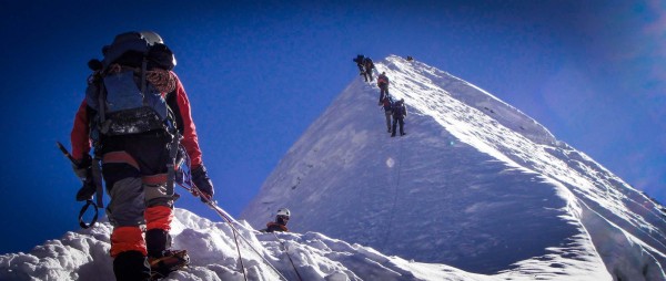
“An epic trekking adventure of three passes with a complete trekking destination of Renjo la, Chola, Kongmala, Gokyo Ri, Kalapathar, EBC, and Chukung Ri in a single trip.”
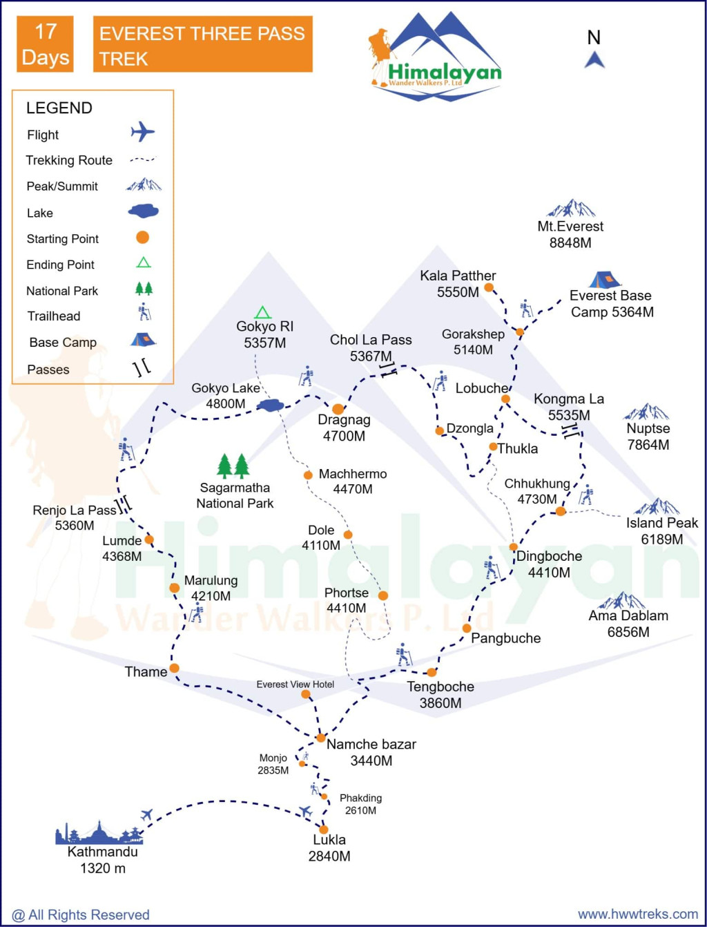
Three passes mean a high pass of Renjo La (5,345 m/17,532 ft), Cho La (5,420 m/17,778 ft), and Kongma La (5,535 m/18,154 ft), which provides a complete trekking experience. Even though it is a challenging it is ultimately the most rewarding trek in the Everest region. This whole package trek is also known as the Khumbu Circuit trek.
This magical trek offers you the opportunity to see much more in the way of breathtaking mountain vistas than the normal trek in Everest. The trek is complemented by visits to Sherpa villages, homes, monasteries, and the herd of mules and yaks, which offer you an insight into the quiet but culturally fascinating Sherpa lifestyle.
Crossing the three passes is not technically difficult, but all these trails need to climb above 5000 meters. Acclimatization is highly recommended on this trek. Many trekkers do three passes from east to west because it's much easier than starting from the west.
If you are looking for a different itinerary than the one here, please customize your trip.
Highlights:
- Trek to the off-the-beaten trail of the rural and rocky mountains.
- Many high passes were spotted with chortens, prayer flags, and stupas.
- Antique Tibetan monasteries, bamboo, and rhododendron forests with grand waterfalls.
- A land of Sherpa people.
- Khumbu glacier and Ngozumba glacier.
- Gokyo Lake and Gokyo RI
- Cho La pass, Renjo La pass, and Kongma La pass
- Everest Base Camp
- Kalapatthar Viewpoint
Include
All airport pick-up & drop by private vehicle (international and domestic)
English speaking, government licensed guide with all his salary, food, drinks, accommodation, transport and insurance
Twin/double Sharing accommodation in the mountain during the trekking
Three meals a day; breakfast, lunch, and dinner during the trek
Arrangement of emergency evacuation service (should have insurance for emergency evacuation and will be paid by your travel insurance company)
Trekking route maps
All necessary government taxes and service charges
Porter (For two-person)
Sharing Transportation to Ramechap
Two way flight to and from Lukla
All Trekking Permits
Exclude
Your Nepal visa fees and 2 passport size photos
All the International airfare from and to Kathmandu
All meals and accommodation in Kathmandu
Food and accommodations in case of early arrivals from the trek or late departures from the airport
Your extra personal expenses during trek such as (laundry, baggage charge, phone calls, battery recharge, bar and beverage bill, boiled or bottled water, hot and cold shower, extra porter, etc)
Tips for the trekking crew
Extra expenses due to flight delays, strikes, weather condition or any event out of our control
Hotel in Kathmandu
Route Map
Fixed Departure Dates ( Limited Seats Available)
| Trip Dates | Trip Costs | Actions |
|---|---|---|

12 Oct, 2026 - 28 Oct, 2026 |
$1850 |
Important Information
CHECKLISTS FOR EVEREST THREE PASS
- Valid passport (valid for six months from the date of your trip)
- MasterCard, Visa Credit, and Debit Cards are accepted in Nepal. However, some cash is highly recommended.
- Mobile (if your cell phone is from CINGULAR USA or ATNT (USA) operators, then your cell phone will work in Nepal.)
- Clothing (Layered clothes, windproof and waterproof jackets, fleece pullovers, thermal base layers, hiking pants, shorts, headwear, footwear, and other items according to your needs)
- Personal Items and Toiletries (First-Aid Kit, Iodine tablets or a UV purifier to treat water, Sun Protection)
- Travel and Health Insurance
- Trekking gear and equipment(if you have your own trekking gear and equipment, such as trekking poles, sleeping bag, and shoes, then you can bring them; else you can rent them in Thamel, Kathmandu). Read more for trekking gears and peak climbing gears.
Guiding, Food, and Lodging
In Nepal, all trekking supplies - Teahouse trekking means staying and eating in local lodges. We stay in single rooms where possible, but often you will have to share. Rooms are basic, normally just a bed with a pillow, blankets. A few have electric lights and all have a spacious dining room-lounge. We eat at teahouses and, although the food is usually plentiful and delicious, the menu is not extensive. They offer a variety of potatoes, rice and noodle dishes, as well as soup and seasonal vegetables. Beers and local spirits are often available, but that will be at your own cost. A variety of cereals, bread, and egg dishes are generally available for breakfast. There are also snacks available such as basic biscuits, chocolate, and soft drinks and in some areas, you will find fresh fruit in season. It is normal to meet your porter in the teahouse where you will stay overnight. So, pack your necessary things in your own day pack.
DRESS CODE FOR VISITING MONASTERIES, AND TEMPLES IN NEPAL
- Shirt (either half or full sleeve)
- Full pants/long skirts
- Any type of shoes with socks
- No Hats, No Umbrella, No Slippers, No t-shirts, No short skirt, and No half-pants
- Photographs allowed in the courtyard only.
Note regarding itineraries
Although we generally adhere to the schedule, the itinerary is subject to change for numerous reasons beyond our control, including weather and terrain conditions, suitable campsite availability, and the group's general fitness level. It is important to understand that our trek is logistically complex and it is not unusual that adjustments be made. Our guide will orient you each evening to the following day's plan; their good judgment is the key to the long history of successful treks that Himalayan Wander Walkers has led till now. Please remember that our ability to make adjustments as needed helps to ensure that your trek is successful.
Frequently Asked Question
Yes, the Everest Three Pass Trek can be fully customized to match your preferences. Whether you wish to shorten or extend your trek or incorporate additional rest days, we can adjust the schedule accordingly. Just let us know your desired modifications, and we’ll help you create a tailored itinerary: “Customize Your Trip.”
The Everest Three Pass Trek is classified as a strenuous trek, designed for experienced trekkers. It involves crossing three high-altitude passes—Kongma La, Cho La, and Renjo La—each exceeding 5,000 meters. The challenging nature of the trek and its high-altitude environment make it essential to properly prepare and acclimatize to prevent altitude sickness and ensure safety throughout the journey.
Yes, having a guide is highly recommended for the Everest Three Pass Trek. The route is rugged and passes through remote areas, where a guide’s expertise in navigation, safety, and acclimatization is crucial. They will not only provide local cultural insights but also assist with logistics and adapt to any unforeseen circumstances, such as weather delays or changes in plans, which are common in Lukla.
For the Everest Three Pass Trek, you will need the Everest National Park Entry Permit and the Khumbu Pasang Lhamu Rural Municipality Entrance Permit, which are required for all treks in the Everest region. Additionally, if you plan to cross the high altitude passes, you may also need a TIMS (Trekkers' Information Management System) card, which helps track trekkers in the area.
Yes, altitude sickness is a potential risk on the Everest Three Pass Trek, as it reaches altitudes higher than 5,000 meters, particularly at the three passes. Proper acclimatization is critical to avoid altitude sickness. The itinerary includes rest days in locations like Namche Bazaar and Dingboche to help with the adjustment. It is vital to stay hydrated, maintain proper nutrition, and ascend gradually. If you experience symptoms such as dizziness, headaches, or nausea, inform your guide immediately so they can follow the necessary safety protocols.
Throughout the trek, you will stay in teahouses and lodges, providing simple yet comfortable rooms and traditional local food. These accommodations offer a warm and cultural experience while also ensuring a good night’s rest to prepare for each day’s trek.
Yes, internet access is available in certain locations along the Everest Three Pass Trek, although it is limited. Mobile network coverage is offered by providers like Ncell and NTC. Additionally, many lodges provide Wi-Fi services, and Everest Link offers prepaid broadband in some of the higher-altitude villages such as Namche Bazaar and Dingboche.
For the Everest Three Pass Trek, it’s essential to pack appropriately for high altitudes and extreme weather conditions. Key items include sturdy trekking shoes, warm clothing (temperatures can drop significantly at higher elevations), a quality sleeping bag, water bottles, sunscreen, a hat, energy snacks, and a basic first-aid kit. Given the challenging nature of the trek, packing light while ensuring you’re prepared for every eventuality is important. Read more about trekking gear.
If you're looking for alternative treks in the Everest region, consider the Everest Base Camp Trek, which takes you to the foot of the world's highest mountain. Another option is the Gokyo Lakes Trek, which provides spectacular views of Everest and surrounding peaks, offering a quieter experience with stunning Himalayan vistas. While these treks are slightly less difficult than the Three Pass Trek, they still deliver incredible views and unforgettable trekking experiences.
No questions found matching your search. Try different keywords or browse all questions above.
| {{type.min}} - {{type.max}} Pax {{type.name}} - {{type.desc}} | {{type.display_price}} per people |
Extra prices:
Let us help you decide Inquiry
You might also like

- 14 days
- Everest Region Trek
Everest Base Camp Trek
Everest Base Camp Trek is the ultimate goal of many people (bucket list) and those who have already been there; they rate it as one of the best experiences of their life. Everest Base Camp Trek is an iconic trekking destination in the Himalayas and probably in the world. The world's...